
Complete Insight on Bangalore Metro Map- Complete Route
Table of Contents
Bangalore, now officially known as Bengaluru and fondly referred to as Namma Ooru (our city), introduced the Namma Metro (our metro) in 2011, also known as the Bangalore Metro, as a single modest stretch of track. With over 3.5 lakh commuters every month, this mass rapid transit network has become a game-changer as India’s 3rd operational metro rail service after Kolkata and Delhi.
The Bangalore Metro is a huge respite for commuters who have had enough of the infamous traffic jams in the city that slow down and impede everyone’s punctuality. The metro connects India’s Silicon Valley’s key residential, commercial, and industrial hubs. So, how does Bangalore Metro stand out? It connects seamlessly, it’s affordable, and it is committed to being environmentally sustainable, thereby providing an excellent solution to gridlocked roads and endless, frustrating travel times.
The metro catalyzes urban infrastructure development. It features an extensive metro route map that ensures uninterrupted connectivity, even to remote suburbs and the city’s heart. Suppose you are looking for the complete map of Bangalore. In that case, you’ve stumbled across the right place where you can explore its routes, lines, stations, timings, and future expansions to redefine the city’s mobility.
Evolution of Bangalore Metro
The Purple Line marked the inauguration of the Bangalore Metro, the first stretch between Biyapannahalli and MG Road. Phase 1 of the metro line started with a stretch of 42.30 Km linking the East-West and North-South corridors through the majestic interchange. The metro’s Phase 2 began in September 2015, extending from Mysore Road to Pattanagere. Phase 2 is still under expansion, planned to extend up to 72 km, which will add routes to Whitefield, Kengeri, and Silk Institute.
Moving forward, Phase 3 of the metro is set to add over 100 km of new lines, which will include the proposed Blue and Orange corridors to connect prime zones such as the airport, Hebbal, and Sarjapur Road. Bangalore Metro Rail Corporation Limited (BMRCL) strategically plans to develop the metro as the backbone of the city’s urban transit.
Bangalore Metro Map - An Overview

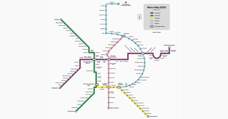
As of mid-2025, Bangalore Metro operates on three fully functional lines:
Line 1 – Purple: (42.17 km, 37 stations) Challaghatta to Whitefield (Kadugodi)
Line 2 – Green: (33.03 km, 32 stations) Madavara to Silk Institute
Line 3 – Yellow: (19.143 km, 16 stations) RV Road to Bommasandra
Commuters can avail multiple interchanges as part of the metro’s connectivity highlights. For instance, Majestic serves as a significant node between the Purple and Green lines. If you want to take the Yellow line from the Green line or vice versa, you can interchange at RV Road, which in turn is being designed to link with the Pink and Blue lines in the near future. All these are charted to improve the connectivity between the East, South-East, South, and central zones.
Let us quickly have a look at how Bangalore’s metro serves the city’s key zones, like the IT hubs (Electronic City, Whitefield, and Bommasandra), central business hubs like Majestic, Vidhan Soudha, and MG Road, residential zones like BTM layout, Yeshwantpur, and Nagasandra, and other significant intersections like Indiranagar. The metro’s coverage is gradually expanding to connect the outskirts with the center, easing traffic and reducing travel time over extended distances.
Detailed Route Information
Currently, the Bangalore Metro route map operates on two major lines:
Purple Line (Connecting East to West)
- Route: Baiyappanahalli to Whitefield (Kadugodi)
- Stations: 23
Major areas that this route covers:
- Baiyappanahalli
- MG Road
- Indiranagar
- KR Puram
- Whitefield
Green Line (Connecting North to South)
- Route: Nagasandra to Silk Institute
- Stations: 29
Major areas that this route covers:
- Nagasandra
- Yeshwantpur
- Rajajinagar
- Jayanagar
- Silk Institute
Yellow & Pink Lines (Upcoming)
Yellow Line
- Route: Rashtreeya Vidyalaya Road to Bommasandra
- Stations: 16
Pink Line
- Route: Kalena Agrahara to Nagawara
- Stations: 18
Major areas that the route covers:
- Kalena Agrahara (Bannerghatta Road side)
- Hulimavu
- IIM Bangalore
- Jayadeva Hospital (important interchange point with the Yellow Line)
- Tavarekere / Dairy Circle
- Mico Layout / Lakkasandra
- Langford Town / MG Road extension areas
- Shivajinagar (central node)
- Tannery Road
- Venkateshpura
- Kadugondanahalli (KG Halli)
- Nagawara (north Bengaluru hub, planned interchange with Blue Line to Airport)
Blue & Orange Lines (Future Expansions)
Blue Line
- Route: Central Silk Board to KIA Airport
- Stations: 30
Orange Line
- Route: JP Nagar to Kempapura
- Stations: 22
Major Areas that the route covers:
- Central Silk Board – interchange with the Yellow Line
- HSR Layout
- Bellandur
- Kadubeesanahalli
- Marathahalli
- ISRO / Doddanekundi
- KR Puram – interchange with Purple Line
- Nagawara – interchange with Pink Line
- Hebbal – key road/rail junction
- Yelahanka
- Jakkur / Bagalur Cross
- Kempegowda International Airport (KIA) – airport terminal station
Bangalore Metro Timings & Frequency
Namma Metro services start at 5:00 AM, and the final metro of the day departs at 10:35 PM. The timing accommodates commuters of all categories, be it office goers, students, or those seeking leisure. Services start at 6:00 AM and end at 10:35 PM on general holidays, such as the second and fourth Saturdays. The first metro on Sundays commences at 7:00 AM and the last metro departs at 11:00 PM.
The city’s metro operates at a convenient frequency for commuters during peak and non-peak hours. The trains run every 5-10 minutes at peak hours and 8-15 minutes at non-peak hours. The frequency may be slightly lower than that of weekday operations.
Connectivity with Other Transport Modes
- Metro + BMTC Buses: Metro feeder bus routes, as MF Series, connect metro stations with local areas.
- In August 2025 alone, 12 new feeder buses were deployed to serve the Yellow Line stations.
- Metro + Suburban Rail Integration: The Majestic Metro Station connects directly to the Bangalore City Junction, facilitating interchange between metro and long-distance suburban rail services.
- Miscellaneous Connectivity Options: You’ll find e-Rickshaws, cab services, and shared autos near the metro exits.
Fare Structure & Smart Card System
The Bangalore Metro utilizes a distance-based fare system, complemented by tokens and contactless smart cards. Fares range from INR 10 to INR 90. The Bangalore Metro offers tickets with QR codes, providing a 5% discount on the ticket fare. If you are in a large group, your group can avail a 20% discount on the token fare. If you are a smart card holder, you can recharge it as per your usage. These cards are available for INR 50 and you can recharge it up to INR 3,000. Namma Metro also provides a monthly pass of INR 1,500 which you can use for all metro lines for a month.
Future Prospects of Bangalore Metro
Bangalore Metro is experiencing rapid expansion to streamline the city’s transport system. Some of the core upcoming developments are:
- Yellow Line: By connecting RV Road to Bommasandra, it will enhance the connectivity to Electronics City
- The Pink Line, connecting Kalena Agrahara to Nagawara, will enhance connectivity between the northern residential areas and the southern suburbs.
- Inter-city connectivity: If you go by the plans, the city’s metro services are expected to expand to the nearby towns of Mysuru and Tumakuru.
Challenges & Opportunities
Some of the challenges that Bangalore Metro faces are:
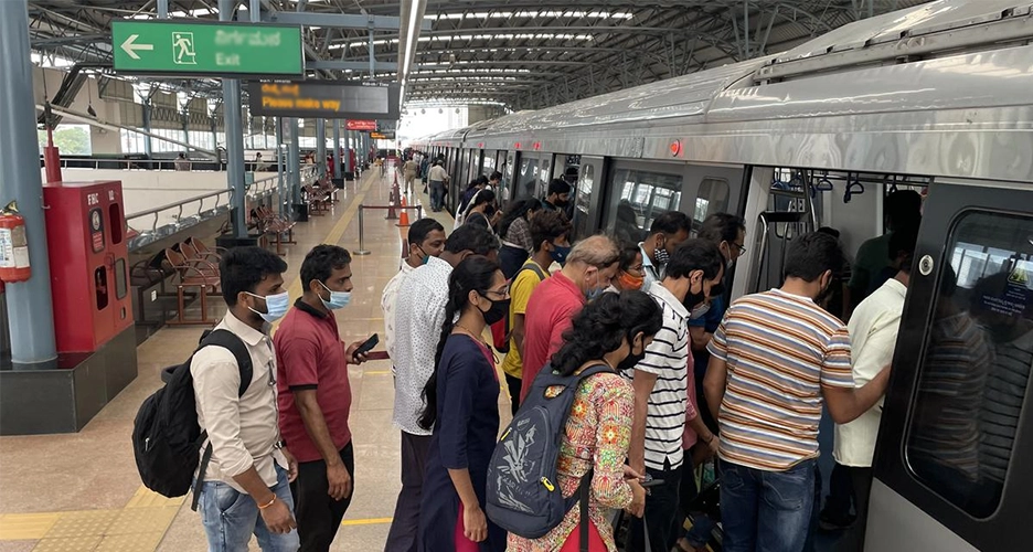
- Peak-hour overcrowding
- Slow speed of construction for extending the metro lines
Opportunities
- Increases your efficiency by cutting off about 50-70% of time as compared to road travel.
- Reduces the city’s carbon footprint
- Monthly passes and low fares make the system budget-friendly.
Conclusion
Finally, to conclude, we can say that the Bangalore Metro Rail Corporation (BMRCL) is doing a commendable job of connecting the city and nearby cities seamlessly, thereby reducing the existing insane road traffic and providing safer, eco-friendly travel options for everyone. BMRCL is required just to pace up construction a little more to redefine urban commute in the city.
FAQs
1. How many metro routes are there in Bangalore?
There are two fully operational lines, Purple and Green, and several under-construction lines, including Pink, Yellow, Blue, and Orange.
2. How to see metro lines on maps?
To see metro lines on a map, you can open the Google Maps app, tap the layers app at the top right, and then select transit, which will display the rail and metro lines on the map.
3. Which is the longest metro route in Bangalore?
The planned and under-construction Pink Line will serve as the longest corridor connecting several stations.
4. What are the stations in the Purple Line in the Bangalore Metro Route Map?
Bangalore metro’s Purple line connects Byiapannahalli to Whitefield (Kadugodi), connecting K.R. Pura, Dr. M.V. Stn., Central College, Sir M. Visveswaraya Stn., Central College, Vidhana Soudha, Cubbon Park, and Nadaprabhu Kempegowda Stn., Majestic.
Stay updated with the latest Developments in Real Estate across top cities – Mumbai, Gurgaon, Pune, Bangalore, Thane, Hyderabad, Delhi, Himachal Pradesh, Goa, Noida, Panchkula, and Dubai to make informed investment or home-buying decisions.
Related Posts:
- Mumbai Metro Route 2026- A Complete Guide for Travellers
- Bengaluru-Tughlakabad Freight Link Opens New Rail…
- Best Residential Posh Areas to Live in Bangalore
- Delhi vs Kolkata: A Complete City Comparison
- Top Under Construction Projects in Bangalore to…
- A Complete Guide of Living in Bangalore (Pros &…
- Top 10 Most Expensive Society in Bangalore
- List of Top 10 Metropolitan Cities in India
- Why Bangalore is Best City to Live in: Pros, Cons, and FAQs
- Bangalore Suburban Rail Project: How It Could…
- Most Expensive Residential Areas to Live In Bangalore
- India's Top Expressways – List of Total Expressways in India
- Sarjapur Projects in Bangalore: The Smart Choice for…
- Mumbai Vs Bangalore: A Metro City Comparison
- Why Devanahalli Is the Future of Luxury Living in Bangalore
- Top 20 Best Places to Live in Pune
- Miami-Inspired Living: The Art of Bringing…
- Top 15 Best Places to Live in Mumbai
- The Significance of Dhanteras: Celebrating Wealth…
- Griha Pravesh Muhurat in 2026: Dates & Month wise Timings
- Property Investment in Yelahanka Becoming Next…
- Delhi Master Plan 2047: What It Means for the Delhi…
- Top 12 Pink Two Colour Combinations for Bedroom Walls
- Embassy Knowledge Park : An Integrated Township…
- Top 15 Best Places to Live in Chennai - Rent,…
- Top 10 Biggest Malls in Mumbai- Your Next Stop for Shopping
- Step-by-Step Process To Buying a House in Mumbai (2026)
- Know The Places to Visit in Bangalore 2026
- Golf Living in Gurgaon: The Story Behind the City’s…
- A Complete Guide of Living in Mumbai (Pros & Cons,…